Today’s post is by guest blogger Christine Celsor
One very important element of a world-class city is an effective transit system. Tourists and residents alike need to get around the city without a car. Transit reduces the amount of energy expended on transportation and reduces pollution emissions. The more efficient and effective the transit system is, the better it improves environmental quality, and the better it contributes to Cincinnati’s urban vitality.
The streetcar is an amazing opportunity for Cincinnati. Urbanists who have great visions for the future of the City have won the political battle. The streetcar is a symbol for those who believe that Cincinnati can be one of the best cities in the country. We can attract and retain new talent, by serving the needs of residents of all kinds – including those who can’t or don’t drive.
The streetcar is just the beginning. Its design might be the beginning of a light rail system that provides fast and efficient connections along heavily traveled routes. Imagine being able to hop on a train downtown and get to UC in about ten minutes, without having to worry about parking. The more the rail network expands, the more useful it will be. The streetcar is also re-defining Cincinnati Metro. Cincinnati Metro plans to redesign the exterior of buses to match the streetcar colors to capitalize on the energy from the streetcar.
Cincinnati Metro has great potential to expand its bus system as well. In most areas, bus service provides good coverage. Currently, however, even when people have access to a bus route, the bus does not come very often and does not efficiently connect origins and destinations. People are not very likely to choose the bus if the trip takes two or three times longer to get to their destination than if they would drive. When there is an extensive network of buses that come frequently, people have many options to transfer and get to many different destinations quickly.
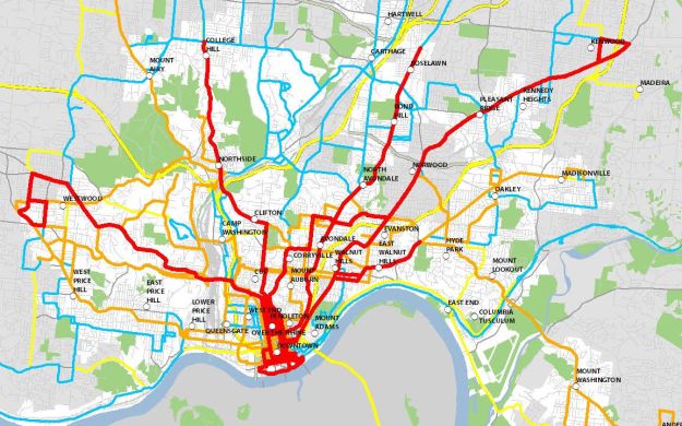
The map below shows existing Cincinnati Metro bus service identified by frequency. Red lines represent bus service every 15 minutes; orange every 20-30 minutes; blue every 45 minutes to 1 hour; and yellow is express bus service. This map is not meant to show every route individually, though it could be made into a map that shows both frequency and individual routes. The intent of this map is to give a big picture of Cincinnati Metro’s strengths and weaknesses. Bus service from many neighborhoods to downtown is very good. What is sorely lacking is at least one frequent crosstown route, ideally more than one. Frequent crosstown routes could turn Metro’s system into a much more usable network.
The next two maps show existing employment and existing population density. Employment density is very important in determining where bus routes will be successful in attracting riders. The minimum employment density to support good levels of transit service is about 10 employees per acre (shown in the lightest purple). The medium purple represents 20-30 employees per acre, and the darkest purple represents 30 or more employees per acre.

 Population density is also important. Ten-to-twenty persons per acre can support good levels of transit ridership (shown in the lightest yellow), and above twenty persons per acre can support very good levels of transit ridership. The darkest yellow-brown represents 30 or more persons per acre. When areas have high employment and population densities combined, they are very likely to support very good levels of transit.
When a city is designed only for cars, it fails both people and their cars. When a city is designed for people, it ends up working for everyone, including drivers who benefit from reduced traffic and parking congestion. Part of Cincinnati’s transit revolution should include improving bus service. Improving bus service is a cost-effective way to make a big impact on the city’s transit system.
The maps provide some useful big-picture information to start thinking about how we can improve Cincinnati’s bus system. How can we connect our neighborhoods better? How can we connect employment centers with residential neighborhoods? How do we make Metro more user friendly? Coming up with answers to these questions and implementing the solutions will make Cincinnati even better.

The best use of transit resources would be to connect human-dense locations with each other in a node-to-node pattern and skip all the low density suburban stops in between. Those may serve the occasional transit-dependent person, but it does so at the cost of a far slower, less effective, and more expensive system. That could include cross town (rather than downtown oriented) routes.
It’s time for transit agencies to cut the suburbs loose and acknowledge the reality that they will always be auto-dominated places. If the suburbs want really good transit (which they almost never do) they can change their land use policy to permit mixed-use infill development in a node of their own first. That should be the minimum litmus test to receive transit service. At the moment suburban nodes are isolated single use shopping centers and office parks. When those massive surface parking lots start to sprout residential infill… then they can get transit.
When you have a discussion like this, bus rapid transit (BRT) has to be part of the conversation. As the author noted, a bus that takes 3-4 times as long as a car to travel is not a real alternative.
The author’s note on a need for a crosstown route is a good one. But you need a system in place like BRT if utilizing transfers is something that’s able to happen functionally. If you can go somewhere using public transit without having to look at schedule times, then you’ll know your system is good.
What is the underlying zonal geography that the employment per acre is based on? The zones look pretty aggregate. I guess what I mean is how evenly dispersed across the zone are these densities?
Hi Daniel,
Traffic Analysis Zones are used to show the employment and population data. This is the standard geography used in transportation planning. The population and employment data was provided by OKI.
-Christine